


 English
  Français
Faroe Islands
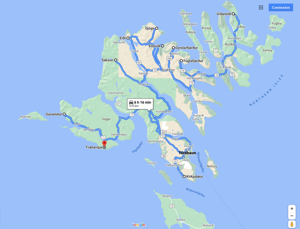
You can click on the map and on pictures to enlarge them
In August 2019, we spent a short week in Faroe Islands, in the continuity of our fifteen days in Iceland, as a beautiful ending to that extraordinary trip to the far North. That volcanic archipelago covered with greenery lost in the Northern Atlantic Ocean between Iceland, Scotland and Norway left us with an unforgettable memory. It enjoys some of the characteristics of the three above-mentioned countries in addition to its own. Some of its nooks look like the back of beyond.
We were kind of leaving towards the unknown, given that the touristic identity of that country is not totally asserted yet. However, it starts to open to visitors from all around the world, and we were surprised to meet Asians and Americans there, whereas it is unknown to numerous Europeans. It can be explained by the proposition of package tours including Iceland, Greenland and therefore Faroe Islands by tour-operators.
Anyway, it was a revelation. Landscapes are as fabulous as in Iceland, certainly less original and less unusual for some of them. Tórshavn, the capital, is the only real town. Small villages run along in seventeen of the eighteen islands that make up the archipelago. You may be surprised at finding them relatively lively, and getting in touch with people there is sometimes easy. Colored houses offer a nice contrast with the landscapes. The country is not much populated, so that there are more sheep than inhabitants! They seem to enjoy considerable freedom and get comfortable so that they take advantage of the exceptional setting they live in. Fjords are sumptuous, and cliffs are impressive; they can reach dizzy heights. Some are jagged, some others seem on the contrary to be drawn out with lines and slightly erected towards the skies. Besides, it is advised not to get too close o the edge, for violent gusts may push you into the void. Moreover, you have to be even more vigilant if you get far from the paths during your walks and hikes: indeed, there are holes and cracks in the ground in places, and the high abundant weed make it hard to be seen.
«Buttercup routes» allow you to cross breathtaking landscapes. Those are scenic roads marked with signs with a buttercup. Besides, many of those nice flowers cover verdant meadows with their much vivid yellow color all over the country. Car rental is highly advised, for many places have a very limited public transport service. We also recommend you to buy the sticker that allows you to enter tunnels. Indeed, there are many of them: thus, it will quickly help cover the cost and it will spare you from paying a certain fee at each passage. Thus, you will make considerable savings.
For lovers, be aware that you can have access to football fields and borrow a ball to play in complete freedom. You just have to ask players who are training or their coach, who will accept willingly, with the kindness and the sympathy that characterizes the Faroese people. Given that old and young alike speak good English, it makes things easier.
And to top it all, we were very lucky with the weather: we enjoyed the sun almost all along. Only the last day was rainy. The young and charming receptionist in Hotel Tórshavn where we stayed confirmed us it was rare. We salute her. Besides, the temperature was less cold than in Iceland, and the winds were less powerful and less biting. We even caught ourselves walking around with T-shirts at temperature of 13°C or 14°C, for we got used to the Icelandic cold during our fifteen days in that fabulous country. Those very favorable weather conditions allowed us to enjoy all the more that trip in a fascinating country that will go down as a red-letter trip.
Streymoy Island
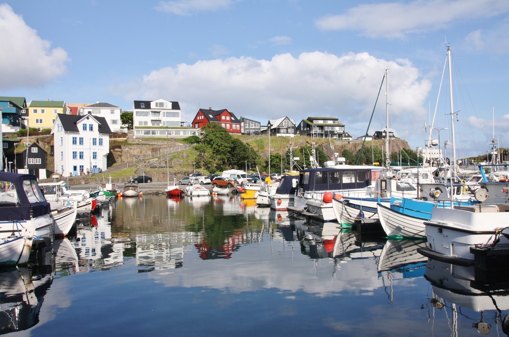
Tórshavn (photo), human-sized capital, has hardly more than 13000 inhabitants. We started our visit with the Skansin Fortress, perched on its grassy knoll. Its old stone buildings are not open to the visit, but you can admire its white and red lighthouse as well as its guns. The view of the town, its port and its colored houses is unrestricted. It allowed us to have a general overview of it before we go and discover its small areas. On the distance rises Vesturkirkjan, the Western Church, which modern and innovative architecture emerges from the rest of the panorama. Without further delay, we headed for the port to enter the small winding alleys of Tinganes district and its lovely stone and burgundy red wood houses with turf roofs. The oldest ones date from the 17th century. There stands the Parliament Pier, which separates the port into two parts. The first Faroese Assembly gathered there about a millennium ago. You got the entrancing feeling to travel to forgotten times. It is much exhilarating and gives you a complete change of scenery. The unexpected presence of a triangular building - burgundy red as well - made us thing of a Faroese Flatiron Building, relatively speaking.
We carried on with the neighboring district Á Reyni, also in the old town. There, tarred wood houses offer a different setting. Red or white doors or windows frames offer a nice contrast with the dark walls, as well as whitewashed low walls, and there too those amazing turf roofs. A Parisian street dark blue sign with green rims is fixed on a house: Rue de la Reynie in the 1st Arrondissement. It is a nice allusion that may explain the name of that charming area.
Dómkirkjan, Tórshavn Cathedral from 1609, rises majestically in the heart of a nice wooded garden. Golden rims beautify its immaculate wooden walls, as well as its burgundy red doors and shutters. Its slate roof is crowned by a nice bell tower including a clock on each side, and on its top a superb black and golden ironwork weather vane. Apparently, Faroese churches are more refined that most of Icelandic churches, even though their style remains sober. The nice interior decoration, much colored, confirms this trend: the ceiling is royal blue, the frames are red, which perfectly harmonizes with the white walls and the varnished light wood benches. Chandeliers hang from the ceiling, and between two chandeliers hangs a model ship. It is much original. The organ, although modern, perfectly fits into that nice interior architecture. Finally, it is possible to reach the upper floor so that you can admire the whole from a different view. On the foot of the building, a superb lush garden displays its armfuls of multicolored fresh flowers.
As you get down, you reach Vágsbotnur, Tórshavn marina, which displays its modern colored gabled façades in front of which stand numerous bars. We went to admire from close the superb old varnished wood sailboat that was moored to the quay. Its hull, with a surprising turquoise color, clashed with the other boats. On the other side of the port stands Fiskakonan, the statue of a woman cleaning fish. Not far, we saw a rather unusual artwork in front of the Öström shop: a female plastic dummy wore a very original dress made of various feathers and branches, the whole in varied colors. As we entered the streets behind to get closer to the Faroese National Library, we came across something even more unusual: whale vertebras covered with moss decorate a house garden! They stand thanks to a metal base. And on the path leading to the house, an arch was formed halfway with two whale ribs and a small vertebra on top. What an imagination!
So, we stayed in the very pleasant Hotel Tórshavn. Our room offered a breathtaking bird’s eye view of the port. It enjoys a very nice bar and restaurant: Hvonn Brasserie. The atmosphere is often young and lively, and it was going full swing during the performance of a jazz trio named Oslo Unknown.
Finally, do not hesitate to go to the Tourism Office from the very start of your stay. Their modern facilities are very pleasant, bright, spacious and functional. The advice they offer is much valuable. Moreover, the establishment has a very precise weather forecast according to island, for the weather in that country can be unstable and vary from an island to another.
Kirkjubøur is a lovely village essentially built with driftwood. We visited it by the end of day as we were coming back from Eysturoy Island. We took a «Buttercup Route» that lined the fjords, offering dizzy views of lakes and villages down below. In places, roads are so narrow that vehicles cannot pass each other. Spaces are provided on the shoulder so that one of them can stand on to let the other pass. On our way, we were surprised to face a sheep that was downright lying on the road: he did not move an inch and we had to drive around it. The respect towards those ovine that populate the country comes naturally. After that funny interlude, we made a stop on an elevated viewpoint before we get to Tórshavn, of which we had a breathtaking view.
Then, we crossed the capital to reach that charming village. Access is by driving from a small mountain along stony paths where two vehicles cannot pass each other, thus requiring you to stand on the shoulder to give properly priority to the one who is driving up. Black houses with turf roofs and red doors and windows frames offered an entrancing contrast with the light green of meadows and cliffs, while harmonizing with the setting. The Saint-Olav Church (Kirkjan í Kirkjubø) emerged totally, displaying its bright immaculate walls under the grazing sun rays that beautified everything they reached. With its cemetery surrounded by a stone wall, it stands beside Kirkjubøargarður, a farm from the 11th century. Also called Roykstovan, it is one of the world's oldest inhabited wooden houses. Very long, it is built on a stone wall base, like some houses in the village. One of its double doors is particularly well-crafted, with wooden red and turquoise frames finely chiseled. Finally, ruins from Saint-Magnus Cathedral (Kirkjubømúrurin), proudly rise, as if it refused to fall into disuse. It is an uncompleted building from the 14th century. In process of being restored, it displays its typically Gothic pointed-arched windows and its Maltese crosses embedded in walls. Nearby, a typical rowing boat moored to a quay overhung its reflect dancing with the barely perceptible movements of the water. The place was idyllic and we did not want to leave.
You take a «Buttercup Route» to reach Saksun, village cut off from the world surrounded by high verdant mountains. A cove once formed a natural bridge, but it was blocked by sand after a storm, thus becoming a lagoon only accessible by boat at high tide. It includes a museum in an old farm from the 17th century named Dúvugarður, as well as a church. The latter was initially built in Tjørnuvík, another village, and then it was dismantled to be rebuilt in Saksun after being transported through the mountains. Its immaculate white color harmonizes perfectly with its green turf roof. Its cemetery with uneven graves and leaning crosses is filled with charm. It is surrounded by a rectangular low stone wall.
Vágar Island
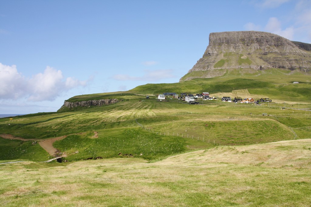
The airport stands on that island. We started the visit with Gásadalur (photo), very charming small village that overlooks the Mykinesfjørður. It is surrounded by the highest mountains in the island. The Molafossur fall flows from the top of a verdant cliff to fall directly into the fjord water. The spectacle is magical and you can admire it from a viewpoint just opposite. We saw some puffins fly in the distance, so we decided to go and observe them from close while taking a hiking path. We walked to a viewpoint that overlooks a cliff. As in Iceland, we were amused by their clumsy way to fly and walk. We observed them and took pictures of them for a long time, trying to capture the moment they took off or landed. On our way back, we took a detour to cross the small village and its tarred wood houses with turf roofs. Some of them have a whitewashed stone base. A picnic table surrounded by solid wooden benches stands close to the remains of a stone wall. In the distance, two rusty tractors rest side by side in a meadow, whereas a lone cabin stands beyond a barbed wire fence. You feel both at the edge of the world and out of time.
Bøur gave us the same impression: that village has various old houses and a church built in 1865. It is mentioned in texts from 1350, but it is probably even older. Some houses under the main road level only let their turf roofs appear. On the horizon, islets with sharp outlines emerge from the smooth water where some rowing boats float casually. The calm is sovereign and soothing.
Then, we went to Trælanípa to go for a hike along Lake Sørvágsvatn, which flows into the Northern Atlantic Ocean. It has no particular difficulty, except a vertical drop on a cliff at the end. The place is cut off from the world: the only buildings you meet on your way are a stone shelter and a house by the water on the opposite bank. Some sheep graze peacefully close to a long stone fence. Further, a wooden bench waits for the hikers who want to take a breath before they start the ascent of the impressive cliff in front of them. Erected obliquely in all its power and majesty, it is the most amazing of all. Once you reached the top, when you get carefully closer to the edge to look down, seabirds swirling in front of their nests seem tiny. It is simply breathtaking. What is even more breathtaking is the visual effect when you get further from it and closer to the ocean: Lake Sørvágsvatn seems to be perched about 100 meters above the ocean, which corresponds to the height of the cliff. But actually, it is only 30 meters above it: it is the high angle shot on the sloping cliff that creates that illusion. That is why it is named «the lake above the ocean». A little further, we saw many rectangular stones on the ground. Their presence there is not without a reason, but it remained a mystery to us. Finally, we climbed big rocks to get closer to the other bank before we come back with our minds filled with images.
Viðoy Island & Borðoy Island
Viðareiði (photo) is a village located on the northern part of Viðoy Island, in the Norðoyar region. It stands on an isthmus made of high mountains from north to south. To get there, we had to take many tunnels. One of them is long, and it is single-track for passage in both directions. Spaces are provided at regular intervals on the shoulder to allow non-priority vehicles to park. Priority is indicated on signs at the entrance of each tunnel. That picturesque small village enjoys a nice white church, which entrance was unfortunately under construction. A stone wall delimits its cemetery, which does not contain many graves. There you can admire traditional colored houses with turf roofs. Steep mountains covered with greenery that drop into the sea are amazing. You can see here and there oystercatchers on rocks. Black sheep and white sheep graze casually behind a staggering barbed wire fence. Nearby, old wood and stone buildings covered with rusty sheet metal try to resist as best they can to ravages of time and repeated assault of elements. But they bring an undeniable charm to that village in the middle of nowhere. Boats float casually near some houses, waiting patiently for their next getaway at sea.
Then, we went to take a walk in Klaksvík, in Borðoy Island. It is the second town in Faroe Islands (almost 5000 inhabitants) after Tórshavn. Anyway, it enjoys a great port where some nice boats are moored. There we admired an old varnished wood sailboat. Its fishing harbor is the largest in the country, and its industrial center flourished for a long time until the end of the 20th century. Finally, the narrow fjord in which the town is embedded is beautiful and spectacular.
Eysturoy Island

Located on the east coast of the island, north of the Varmakelda hot spring, Fuglafjørður is known for its important cultural center recently established. An imposing shipwreck with a pale blue hull lies on the beach in front of colored houses. We were amused by unusual rusty metal sculptures that rise on the colorful port in front of fishing boats and pleasure boats. Nearby, picnic tables coupled with benches were installed; one of them features the colors of the Faroese flag. In the center rises the Statue of Victor Danielsen, a famous Faroese writer. That artwork is owed to the Faroese sculptor Hans Pauli Olsen. The originality lies in the marble base that stretches out lengthwise: the statue is in front, and in the back stands the sculpture of a big hand writing with a fountain pen.
Fuglafjørður is linked by a hiking trail on the former overland mail routes to Oyndarfjørður, north-east of the island. Isolated by a fjord and overlooked by the Sandfelli Mountain, it is one of the oldest villages in Faroe Islands. It dates probably from the Viking era. As for its church, it was built in 1838. Surrounded by pasture, it lives off sheep farming and fishing. There, we felt much enjoyable peace and change of scenery.
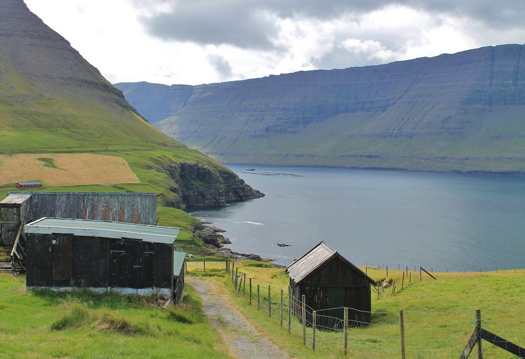
We carried on with Elduvík (photo), very charming small village separated in two on both sides of a river: on the left bank stands the center where much colored houses and lovely gardens abound. Near a house stood an old manual grindstone that brought us back to a bygone era with certain nostalgia. On the right bank, small colored rowing boats lie on the access ramp in front of nice wood and stone fishermen cabins.
We made an unplanned stop in Funningur, which we noticed from a «Buttercup Route» along the cliff, offering an unrestricted bird’s eye view of that charming village surrounded by mountains. Grímur Kamban, the first Viking who settled down in Faroe Islands around year 800, would have specifically chosen Funningur. The church with a turf roof, which dates from 1847, is filled with charm: made of tarred wood, it stands on a whitewashed stone base. Surrounded by a stone low wall, it is very close to a small brook flowing into the sea.
Then, we reached Gjógv, another picturesque village with colored houses in the north-east of the island. Its name means «ravine» in Faroese. Indeed, its port is landlocked below in a very deep fault. You can go for a hike from both sides of that strange open wound in the mountain rock. The one on the left bank is longer and steeper, but you have to pay DKr 50 for its second part. As we were moving from the center, we came across a large private garden overwhelmed with decorations: some were frenzied, other very creative, notably a composition of shells. It was a real mess, but it gave the neighborhood life and color. On our way back, we passed by a small-scale model of a white wooden house with red doors and windows frames… not forgetting the traditional turf roof! Nearby, we were seduced by a house with an old-fashioned charm and an outdated decoration: a small sailor doll with a uniform was looking through the window, near a very old phone that showed through slightly behind dirty windows panes. The whole had an undeniable charm.
Eiði is located north-west of the island. We started the visit with a viewpoint that faces the northern entrance of the Sundini Strait, which drops into two cliffs, thus offering a breathtaking panorama. A green small house seems to be lost in the middle of that vastness. Then, we reached the port, located in a fault in the cliff, and composed of two dikes. A nice typical wooden rowing boat was lying on an access ramp. Perched on the hillside, a cabin covered with a turf roof seems to stand guard on the site. After that, we went to a pebble beach surrounded by cliffs that stretches in an idyllic setting. Behind, the Niðara Vatn lake reflects the mountains that rise beyond the village. Unfortunately, it is known for being the local scene of the Grind, tradition considered as ruthless and barbaric by some people, which consists in hunting pilot whales making them strand on the shore, to be slaughtered afterwards. The smell of putrefaction of dead bodies rotting there was pestilential. As we were leaving the village headed for the north, we made a stop on the side of a coastal road to admire the Giant and the Witch (Risin Og Kellingin), two amazing rocky formations. According to the legend, they came from Iceland at night. They found so much beauty in Faroe Islands that they decided to haul them back to their country. So, they put a rope around the Eiðiskollur Mountain and started to pull and tug. But they finally forgot the time and when the sun’s first rays shone on them, they turned to stone.
Published on December, 20th 2020
