


 English
  Français
Iceland
You can click on the map and on pictures to enlarge them
In July and August 2019, we took a flight to Iceland, land of sagas, legends, one-of-a-kind island where varied landscapes run along and have one thing in common: they are like no other and give you the impression of having set foot in another planet. Indeed, some of them are like the perfect setting for a science fiction movie and deeply agitate us before they leave us with an unforgettable memory. The numerous climate hazards contribute towards their inexorable beauty: the weather is always changing, and that is favorable to natural light effects that embellish the panorama. There, we met people who combine human touch with sobriety and discretion, for whom simple happiness is a second nature, in the finest Scandinavian tradition.
Beyond one-of-a-kind sites, the length of days was exotic to us as well: seeing sunset at 11:30 P.M. and sunrise at 3:30 A.M. had something both disorienting and gratifying. All those things make it a unique country. Unfortunately, it is also a reason why Iceland is the victim of its own success and has difficulty dealing with its stream of visitors, at least during the summer season. Some infrastructures are no longer fitted and get quickly overwhelmed, notably Keflavík International Airport. That being said, only tourist sites are concerned. But if you move away from them, it gets easy to find yourself in the middle of nowhere into communion with a breathtaking nature.
We chose guesthouses as type of dwelling most of the time. That allowed us to get in touch with very likely locals. Besides, given that those were often cottages lost in the middle of nowhere, we started dreaming and had the feeling of living in a house in the open countryside for a night or two.
However, an imponderable spoiled the start of our trip: indeed, our flight from Paris to Reykjavík was canceled because of a major technical problem. We were only able to leave the day after, moreover with a four hours delay! That deprived us of a day in the capital, where J.R.’s girlfriend - who was already there - was waiting for us and shared that unforgettable trip with us. So, we threw ourselves wholeheartedly in the visit of that incredible country as soon as we arrived to forget that frustration and make up for those numerous hours that were withheld from us. The adventure could finally begin.
Reykjavík & Reykjanes Peninsula
The evening we arrived in Reykjavík, we took a walk on Sæbraut (path along the ocean) as we got off the restaurant. Modern buildings that run along there are not much aesthetic, but the place is nevertheless pleasant. There, we admired Sólfar («Sun voyager»), metal sculpture that represents the structure of a Viking ship, and also with a little bit of imagination a fish skeleton. Then, we joined the amazing Harpa building, both a concert hall and a convention center. It is made of a steel frame covered with glass panels of different colors that remind basalt columns.
After that, we left the seafront to take a walk in the streets of the city center that has many shops, bars and restaurants. Façades are much colored and decorated with nice murals. Some shops display illuminated signs that are frenzied, to say the least, notably the one of the gift shop Pride of Iceland, displaying a sheep with the head of puffin in the front, and the head of a Viking in the back! As if they wanted to sum up Iceland with a single hybrid being.
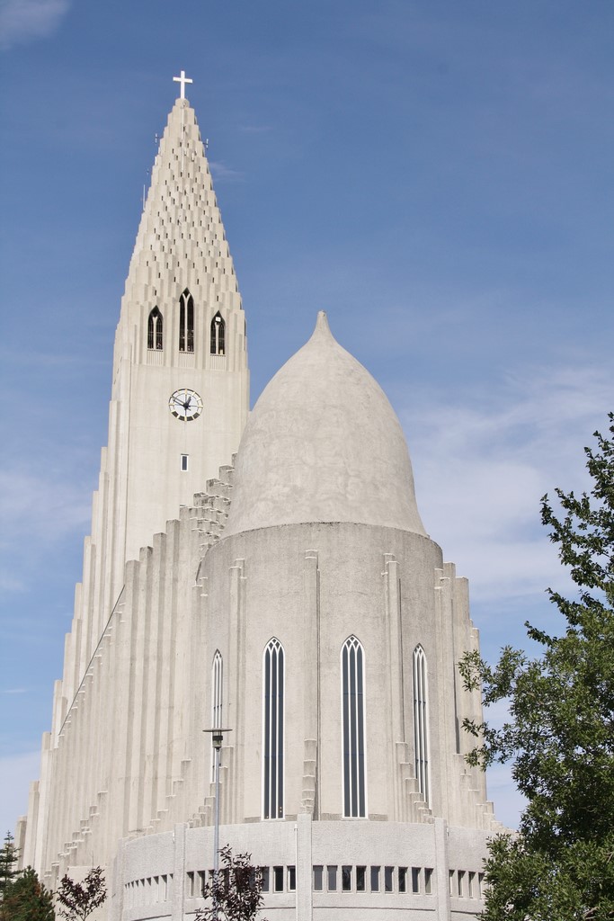
Some straight streets, sometimes slightly steep, open into the ocean in perspective, reminding us San Francisco, relatively speaking. We ended with the famous Hallgrimur Church (Hallgrimskirkja) (photo), idealized image of the city, which amazing slender architecture is inspired by natural basalt organs in Iceland. Given the late hour, it was closed, but we were able to enter it when we were back to the capital at the end of our trip. We climbed to the steeple, defying the violent wind that rushed into it: indeed, there are no windows nor stained-glass windows, but only bars. That being said, the 360° view of the whole city and beyond from a considerable height is breathtaking. In front of it, the Statue of Leifur Eriksson, the first European who reached America, proudly rises.
Then, we visited the city center, by day that time. In the gay district, a rainbow covers the asphalt of the main street lengthways. In front of some shops of the main commercial street stand big paddled puffins or trolls statues, with such a realistic ugliness that they scare some children. Many murals cover walls, notably the one that shows a tutorial about the various ways to tie a tie, very original. It was Saturday and the place was much lively. The atmosphere was easy-going and the ambient happiness was almost palpable.
And then, I separated from them and moved away from the center to get lost in rather residential neighborhoods crossed by Snorrabraut, fairly busy main road that detonates with the peace and quiet of the area. I made a stop in Kjarval Museum, dedicated to the most famous Icelandic painter: it is very well designed, spacious and bright. Further, the nice Háteigur Church (Háteigskirkja) offers a contrast with most of places of worship with a very sober and sleek style that you can find all around the country. Its four slender and sharp steeples proudly display their harmonious outlines.
After that, I went back to the center to get closer to the City Hall (Ráðhús). That modern building overlooks onto the very pleasant Lake Tjömin, surrounded by nice houses and some buildings with an old-fashioned charm. The Free Church of Reykjavík (Fríkirkjan í Reykjavík), nice white edifice with a green roof, rises near the National Gallery of Iceland. Nearby lies the splendid Hallargarðurinn garden. There, an opulent white and purple house proudly displays its porch and its columns. In front of it stands a bandstand inspired by Asia that can remind a pagoda with a little bit of imagination. Some nice statues complete the picture.
Finally, we went to a bar, then in a restaurant, before we linger again to immerse ourselves with that festive energy, so typical of that city well known for its numerous concerts during the weekend, especially in summer.
The day after, J.R.’s girlfriend left us at dawn: it was time for her to go back to France. After we visited the Reykjanes Peninsula (see below), we both spent the afternoon exploring the capital again. We separated from each other and I went to Perlan, great dome shaped glass and steel building on top of a woody hill located on the outskirts. At the beginning, it only had a function of public utility: indeed, it houses big hot water tanks that supplied the city. Then, extensions were created in order to make it fun as well: from now on, it has a museum, a bar, a restaurant and a shop. In the museum stand notably the actual size statue of a polar bear with astounding realism, and a giant size insect. The 360° all-glass top offers an unrestricted view of the city and its surroundings.
After that, I took a main road that notably runs along the nice Hólavallagarður Cemetery, much wooded and shaded with old graves. I reached the seafront close to the Seltjarnarnes Peninsula to head for the Old Harbor (Höfn), where turquoise old fishermen’s cabins now house restaurants and various workshops. On my way, I admired splendid murals, bigger than the ones in the city center. The district is also known for its concentration of museums on diverse topics. I went to the Sod (Þúfa), imposing grassy half-sphere which top you reach by taking a spiral path. On top, an openwork wood shed is used as a fish drying rack. Opposite rise the avant-garde singular outlines of Harpa with its varying shades.
Finally, we met again in the city center to enjoy our last night in that very pleasant capital.
So, on the last day, J.R. and I dedicated the morning to the visit of some sites in the Reykjanes Peninsula. We started with the Bridge between continents (Brú Milli Heimsálfa), which spans North-American and Eurasian tectonic plates. It is a unique place, for most of tectonic plates meet at the ocean floor. So, we felt privileged to find ourselves at that specific spot. The weather was cloudy, cool and windy… so windy that we were not even able to walk around Lake Graenavatn, next step, which amazing green color is due to crystals and algae. Indeed, we only stayed a few moments out of the car to admire it and take as best we could some pictures, for the wind was too violent. However, Seltún, which is only a few hundred meters away, was strangely protected from Aeolus’ repeated assaults and we were able to visit it serenely. That site slightly reminded us Hverir, near Lake Myvatn (see the section «North-East» below): it is also a geothermal field with boiling «witch’s cauldrons». The sulfurous ground colored in yellow, orange, blue and gray spit relentlessly their fumaroles. A small hill rises, on top of which you can get to admire that surreal scenery entirely. A little further, we went along Lake Kleifarvatn, in the heart of an extraordinary setting. At first, the landscape is rather flat, but it becomes steeper thanks to both beautiful and tormented volcanic features. Surrounded by black sand beaches, it is 97 meters deep in places.
South-West
After we left Reykjavík, we went to Þingvellir, which is both a historic site and a national park. It is part of the famous Golden Circle, as well as Geysir geothermal field and Gulfoss fall. It is located east of the capital in a rift valley caused by the separation of two tectonic plates (North-American and Eurasian), with rocky cliffs and cracks as the huge Almannagjá fault. It is famous for Alþing, where the Icelandic parliament took place from the 10th century to the 18th century. There, we also admired the Þingvellir Church and the ruins of old stone shelters, as well as Öxarárfoss fall.
So, we carried on with Geysir, site at the origin of the word «geyser». The spot is surreal: the blue color of the water stands out against the ocher color of the ground from where numerous fumaroles rise. The «witch’s cauldrons» are like the open wounds of a suffering land. Black murky water is boiling relentlessly inside, and bubbles of ephemeral existence burst on the surface. The water is 90° or 100° Celsius, and signs warn you about the danger. The geyser itself erupts every 5 or 6 minutes with almost the precision of a metronome. Astounded visitors press up all around, waiting for the start of the show, always welcome by screams of wonder and applause. The stench due to high concentration of sulfur burns your eyes and nostrils, but the place is so fascinating that you forget it quickly. We climbed to the top of the hill behind to admire it with a panoramic bird’s eye view.
Finally, we finished off the famous Golden Circle with Gullfoss, which is a succession of two falls in the heart of greenery located on Hvítá river. Its name means «golden fall» because of the rainbow you can often see above. The site was the scene of fascinating facts: Sigríður Tómasdóttir, the owner’s daughter, threatened to throw herself into the falls if the river was exploited to generate electricity. So, the building project of a hydroelectric power plant was canceled. At the entrance, you can see a statue in her effigy. The site is amazing, and an incredible strength emerges from it.
Then we reached Flúðir, small village with a population of around 400 people. There, we took a bath in the Secret Lagoon, which water is 38° Celsius thanks to hot springs that supply it with water. The contrast with the outside coolness was striking. Admission is charged and the place is equipped with a reception, a shop, showers and lockers, but it is off the beaten tracks of tourism, contrary to the famous Blue Lagoon, that we preferred to avoid. The lagoon is surrounded by a boardwalk lined by small boiling water springs, in front of which signs warn you about the danger as in Geysir. We got out of there with a sense of well-being.
The day after, we visited Stöng í Þjórsárdal, an isolated and not much popular archaeological site in the Þjórsárdalur region. Those are remains of Viking farms from the 10th and 11th centuries. They think they were destroyed in 1104 after an eruption of Hekla, volcano located nearby. The remains were excavated from 1939 and a replica of one of the farms was rebuilt from 1974 to 1977 during the festivities for the 1100th anniversary of the country colonization. That set forms the Þjóðveldisbærinn Museum. We had to take a difficult track to go there. We had a SUV, but a 4WD vehicle is ideal. The temperature rose to 25-26° Celsius, by far the highest of our trip.
Then, we took the famous Route 1 to reach Seljalandsfoss, much more popular with tourists: it is a nearly 65 meters high fall. A wide cavity allows you to pass behind it, which offers an impressive and unique view point… if you are not afraid to get sprayed. There is a succession of various falls along the imposing rocky wall covered with greenery. Gljúfrafoss, the last one, is located in a narrow canyon, which allows light beams to enter, thus creating an amazing effect of shade and light. You take off your shoes to have access to it, walking in a few centimeters of cool water.
Further, we made a stop by the roadside to admire from the distance the Eyjafjallajökull (photo), ice cap which Eyjafjöll volcano made the headlines in 2010 after its eruption that paralyzed the air traffic for a long time in a part of Europe, because of its thick volcanic ashes dispersed in the atmosphere. And then, we went to admire Skogafoss, 60 meters high fall that look like a curtain in the heart of a green and hilly landscape. Stairs allow you to contemplate it from its top.
At the end of day, we hiked to the Mýrdalsjökull glacier and its amazing set: there, the ice is covered with volcanic ashes, which creates play of white, black and gray colors sets in beautiful patterns. In front of it extend volcanic rocks, and behind rise small mountains covered with greenery. Those unique and lunar landscapes give you the impression that you just landed on another planet.
In the evening, we reached Vík í Mýrdal, a small coastal village with a population of around 300 people well known for welcoming some colonies of puffins. We were lucky to see some of them in Víkurfjara, surprising black sand beach on which some decorative cairns lie. Opposite, impressive rocky spurs emerge from the water, like dark ghosts arose from nowhere, which give the site an even more dreamlike and fascinating dimension. The much coveted birds nest in cliffs, and observing them was a real enchantment. We found them endearing and funny with their lumbering and clumsy way to walk and fly.
The day after, we doubled back more than twenty kilometers along Route 1 to go to the Sólheimasandur site, where lies the wreck of a plane from the US Navy, a Douglas DC-3, which crashed down on a black sand beach in 1973. The aircraft had just delivered some military equipment. On its way back, it underwent a sizable ice deposition on the cabin, which considerably weighted it down. Given that it could no longer maintain cruise altitude, it had to make an emergency landing, and had no other option than finding itself on a frozen river which ice gave away under its weight. Fortunately, none of the seven crew members were seriously injured. You have to walk a long straight line in the middle of a desolate landscape from the parking to reach it. Entering the cabin sends shivers. However, we had to confront the fury of raging elements on our way back: a wind with an incredible power came from the ocean and the rain came whipping us on such a stinging way that we thought it was some hail. It even went through my windbreaker with a cotton lining. Indeed, the region undergoes the worst climate in the country, much rainy and much windy, so that it is strongly discouraged to get too close to the edge of a cliff, for a simple gust could push you into the void!.. As long as we remember, it is the most terrible weather we have ever met during our trips.
As were leaving, we went back to Vík í Mýrdal to visit its church, perched on a small grassy knoll. The style is rather sober and uncluttered, which is besides the case for most of places of worship in Iceland. However, the varnished wooden organ is really splendid. And as it is possible to have access to it, we could admire it from close.
Finally, we took Route 1 again along many kilometers to the East. We made a stop in Eldfellshraun, stretch of land formed by the lava flow in 1973. It is made of an interlacing of paths that go down to the Skansinn Fortress and to a coast with small black sand beaches, the Gaujulundur garden on lava and a lighthouse. The colors scheme between the red and brown land, the black lava and the greenish lichen that covers it is fascinating.
South-East
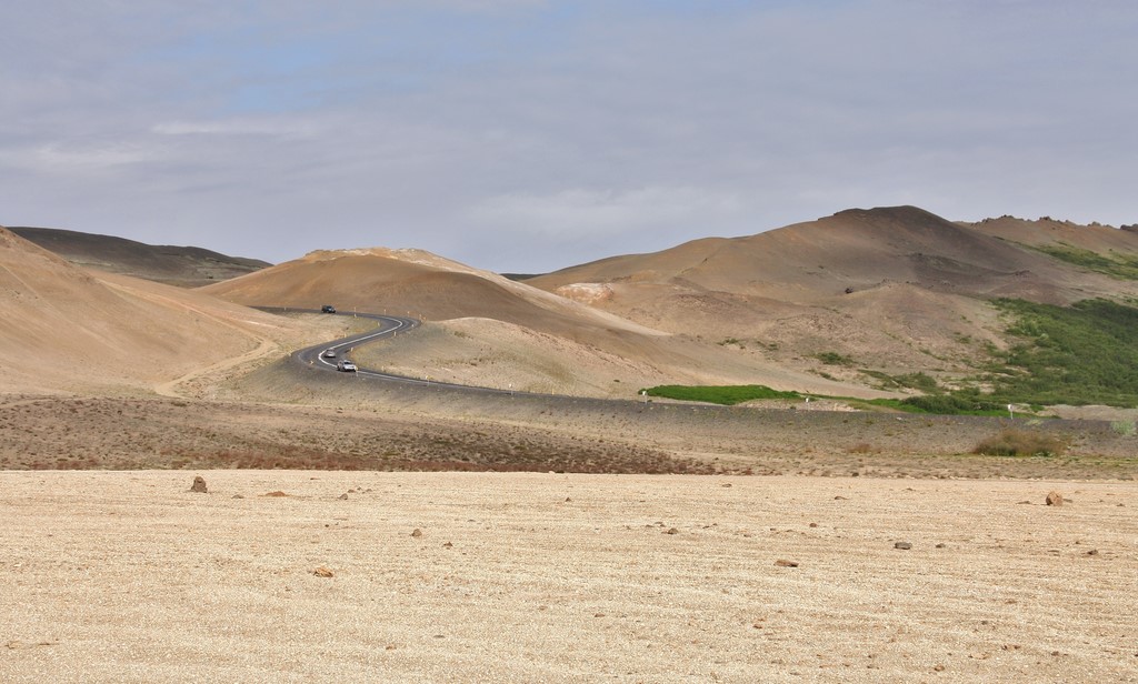
It is the region in the country where we crossed the most remote places of our trip. Its wild open spaces reminded us Western America, relatively speaking. Sometimes, we found ourselves in the middle of nowhere eating kilometers, which was fascinating and disoriented us much. However, places to eat, supermarkets or mini-markets, gas stations are rare there. So we decided to apply the same rules as during our trips across the Atlantic: not to wait the last moment to eat or buy some food and drinks, nor to fill up the car.
We started with the Svartifoss site, in the Skaftafell Natural Park, which is part of Vatnajökull National Park. It is one of the most beautiful falls in the country: it flows from the top of a rocky wall made of surprising basalt columns that give it that so particular shape. To get there, you have to walk along a steep hiking path from the camping, but it is worth the effort! Then, we crossed a footbridge to Sjonarsker (photo), a major viewpoint in the natural park: it enjoys a breathtaking view of Morsárdalur valley. Then, we realized the vastness of the park. A panoramic table indicates the various sites in the region. Mauve and yellow flowers brighten up the green areas that cover the rocky ground in places. In the background, snow-capped anthracite mountains rise. Then, we took a different path on the way back, passing in front of two semi-detached typical houses with turf roofs which interior you can visit. The decoration brought us back to a bygone era marked by certain nostalgia: old wood-burning stove, old cooker, old sewing machine...
We went back to the starting point, and we walked along the trail leading to the Vatnajökull glacier, the largest in the world, which thus gave its name to the national park. There, we found nearly the same characteristics as on the Mýrdalsjökull glacier. A small lagoon extends its turquoise surface, and a little further, small icebergs float casually on a lake. We took an unforgettable long hike on that same glacier the day after, accompanied by a tour guide. We were provided the necessary equipment: ice ax, crampons, shoulder belts etc… The weather was fine: big sun, only thwarted by some white clouds, which allowed us to enjoy that extraordinary spot fully.
In the afternoon, we went to admire the astounding Jökulsárlón lagoon, where an ice tongue from Vatnajökull breaks up into small icebergs with sparkling bluish tints and surprising shapes. Then, we passed on the other side of Route 1, on the Breiðamerkursandur site, violently windswept, where icebergs drifted and ran aground on Diamond Beach by way of the channel. Their translucent appearance offers a striking contrast with the black sand.
After that, we got back on the road to take a walk on Ósland Natural Preserve in Höfn í Hornafirði, charming much colored harbor village. In the background, we could see the mountains and the huge glacier.
Finally, we reached the Stokksnes Peninsula. We crossed wide meadows where some horses and sheep live, between mountains and windswept cliff-edged black sand beaches populated with seals, eared-seals, and seabirds. We ended with the visit of a remarkable Viking village created for the movie «Vikingr» from the director Baltasar Kormákur, near the Viking Café Guesthouse. We really had the impression of being back in time centuries ago. Everything is there: turf roofs, sharp stakes fences, dungeons, moats… All of it was made with astounding realism.
Eastern Fjords
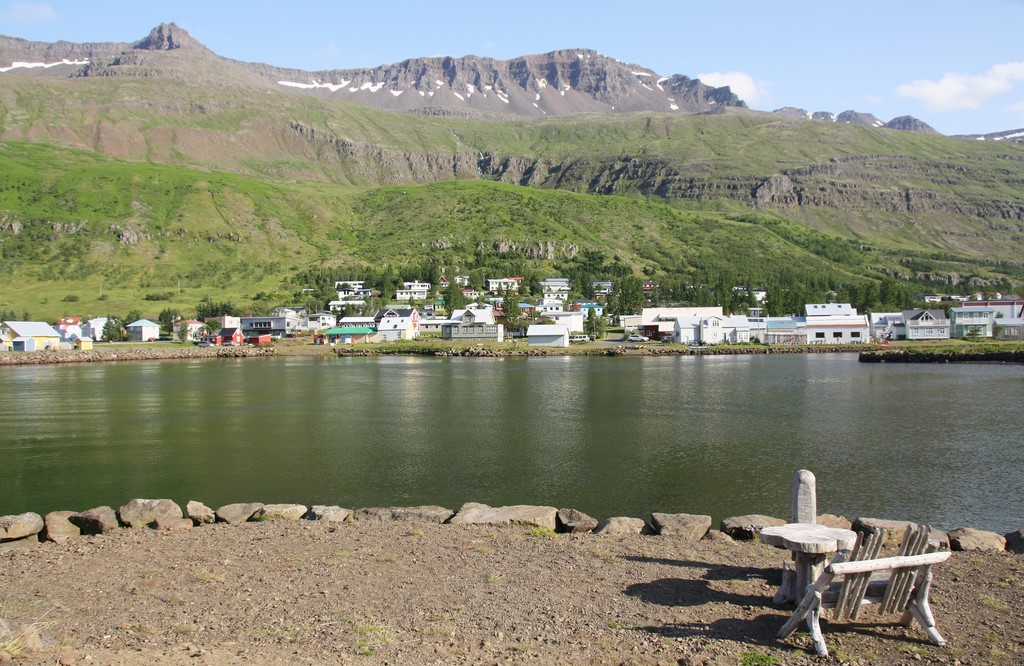
It is one of the most beautiful regions in Iceland. A very jagged coast fitted by winding roads with breathtaking views is offered to marveled visitors. Small colored fishermen villages filled with charm run along there; they look tiny in front of those mountains covered with greenery that drop into the ocean.
The first one where we stopped was Djúpivogur. Much authentic, it enjoys an old port where some fishing boats are moored to old wooden wharves. The walk along the coastal path is very pleasant. A small pond seems lost among steep rocks. Some seabirds made that place their home, notably arctic terns.
We ate in Breiðdalsvík, at the Kaupfjelagið Art and Craft Cafe: it houses a snack, a delicatessen, and a craft and gift shop. The decoration is charming: old collection pieces, old posters (notably vintage Coca-Cola advertising posters), an old sewing machine… Food is rather varied and you can find organic products there.
Then, we reached Stöðvarfjörður, village dominated by the white and blue former Kirkjubær protestant church perched on its grassy knoll. It now houses a hostel. Some street-art works liven up the place, notably murals on a warehouse. J.R. and his girlfriend were lucky to see a puffin near a pontoon.
Fáskrúðsfjörður, our next stop, is a village with a population of a little more than 600 people. It has a French district, for it was a military base for French sailors in the early 20th century. They are owed the chapel and the hospital. They also had a dedicated cemetery. Besides, some streets names are mentioned in both languages. Finally the village is twinned with Gravelines.
About twenty kilometers further, Reyðarfjörður did not leave us with a lasting memory. However, the fjord to which it owes its name is both beautiful and very singular: indeed, a bank made of massive rocky walls stands in front of hills covered with greenery.
We carried on the discovery of that superb region the very next day, starting with Fjarðabyggð, small village cut off from the world that we reached taking a twisting track that goes down along a fjord, offering us splendid bird’s eye views at every bend. It stands in an idyllic setting. There, we admired Icelandic horses, some of which with a chestnut coat and a long blond mane. On our way back, we made a stop to take a closer look at the rusted wreck of an American cargo.
Then, we went to Seyðisfjörður (photo), rightly considered as one of the most beautiful village in Iceland. That is the reason why we lingered there for long hours. Nice colored wooden houses run along the narrow and steep-sided fjord. The church is provided with a nice light blue color and its architecture is more refined than most of places of worship in the country. Art galleries are numerous; works are both funny and creative. The almost permanent show of ferries from Denmark that bring streams of visitors stains a little bit the setting, for their imposing outlines become intrusive. But the undeniable charm of that village quickly takes over and you finally forget it. Moreover, the place is rather lively and the atmosphere is pleasant. Various hiking paths allow you to visit the surroundings more fully. We embarked on the ascent of the sides of the fjord to a fall, from where the view of the village and its port is uninterrupted.
North-East
It is a region with numerous much varied sites. Volcanic activity there is significant, and the climate is milder and dryer than it is in the South. We started its discovery with a hike in Ásbyrgi Canyon, which is a natural horseshoe named « fortress of gods». Its highest cliffs are 100 meters high. In its heart, a tortuous birch and arctic willow forest unfolds, as well as its network of very pleasant paths, one of which leads to the refreshing Lake Botnstjörn.
Then, we made a stop in Dettifoss, simply the most powerful fall in Europe. It is not the most aesthetic in the country: the water there is murky, or even muddy. However, the spectacle is really impressive: a true force of nature in front of which you feel very small, the more as you can get close to it. Nevertheless, you must be vigilant, for rocks are wet and slippery. Obviously, it sends a significant quantity of mist. To have access there, you go for a short hike in Sanddalur Valley, where small lakes run along a landscape made of black sand and basalt columns.
The day after, we had a big day: we started with Námafjall (or Hverir) (photo), small mountain located east of Lake Mývatn and which is part of Krafla caldera. The sulfur gives the ground a strange and fascinating yellowish color. It is so concentrated that the smell is unbearable: it burns your eyes and nostrils. The ground is overheated and it is strongly unadvised to get out of beaten tracks. Huge «witch’s cauldrons» boiling make you feel like you took one step into Hell. We climbed to the top of the hills, thus enjoying a wide bird’s eye view of that unique site. On the other side, we could see the Mývatn Nature Bath (equivalent of the Blue Lagoon), and the Bjarnarflag geothermal power plant and its «Blue Lake» that extends its turquoise surface. But contrary to what its nice color could make you think, its water is very toxic!
We took the time to admire it, before we go to the Stóragjá y Grjótagjá site, where an eruptive fissure houses hot water springs. You can soak your feet inside, but swimming is now forbidden: indeed, the temperature can soar dangerously and the presence of algae was detected, some of which could be harmful. Like many sites in Iceland, the place is private and belongs to farmers who enjoy a wide land.
And then, we reached Hverfjall volcano, which massive anthracite outlines rise more than 400 meters high. Very steep paths lead to its top, offering a breathtaking view of its gaping crater. We walked all the way round, admiring Námafjall and Lake Mývatn in the distance. We got closer to the latter to visit Höfði, a small park that lines it. The amazing lava pillars seem to stand guard on islets and lakes surrounded by forests planted with various species of trees, notably birches and spruces. That diversity brings a mix of very pleasant fresh smells when you take the small shady paths. One of them leads to a very nice clearing, where buttercups display their yellow color in the heart of a green meadow. Some rocky promontories offer beautiful views. The water is so clear in places that the bottom shows through slightly.
After that, we took road 863, where we saw with amusement an outdoor shower a few meters from the shoulder. It is available to the public and the water is naturally heated thanks to geothermal activity. We climbed Víti crater, located at the foot of Krafla volcano. The water accumulated there to form a nice blue lake. A short hike allows you to reach the top, but you cannot totally walk around it.
Finally, we ended that very full day with the Leirhnjúkur volcanic site, nearby. As in Hverir, you can find boiling «witch’s cauldrons» and portions of yellow ground due to the concentration of sulfur. Fortunately, the smell is much less unbearable. We moved forward to an active volcanic area. Significant still hot lava flows cover a large surface, and fumaroles emerge from it. The hiking path has nothing difficult, but you must be careful to the dry lava that can break and become sharp in places. That lunar landscape like the perfect setting for a science fiction movie is simply fascinating.
The day after, we started with Goðafoss, the «fall of gods». It is made of three falls spread over horseshoe-shaped rocky walls on the Skjálfandafljót river. The site is located in the heart of a verdant valley where some farms run along. Even though they are less impressive than Dettifoss, they emit much power. We took the time to admire them walking along the two banks, linked to each other by a footbridge.
Then, we reached Akureyri, second city in Iceland. We felt good there from the very start. It exudes a certain sweetness of life and it is relatively lively in places. We were pleasantly surprised by the heart-shaped red lights! It is nice and original, and the waiting seems shortest. Some colored buildings brighten up the streets, some of them enjoying a both nice and sober architecture. It clings to the south bank of Eyjafjörður, and its port is very pleasant. A beautiful varnished wood sailboat was moored to it. At the entrance of the city, «Sigling», modern sculpture, displays its slender outlines close to a nice summer-house. Nearby proudly rises the theater, beautiful cream-colored building with its gables and its turret. We separated from each other, and as J.R. and his girlfriend reached the heights to visit the botanical garden, I went to admire some beautiful colored town houses in residential streets, then I walked to the warehouses to take the pleasant promenade by the water at the level of the Icewear Visitor Center, annex of the one in the city center. Opposite stands a showroom. Beautiful large size pictures are put up outside, near a superb old hand-operated mangle with an old-fashioned and nostalgic charm. We met again in the lively and colored streets of the city center, where stand many bars and restaurants. Like in the streets of Reykjavík, unusual statues of Vikings, trolls and witches scare the most sensitive children.
We spent the night in the Skjaldarvík Guest House, in the outskirts of the city. It is a real traditional cottage. The interior decoration is really splendid. The living-room is filled with an old-fashioned charm, with its bookcase full of old books and its telescope set up in front of one of the windows. The mansion is wide, and we took an evening walk to admire their nice Icelandic horses. It is a very specific breed of horse: they are short, stocky and they have the particularity of being able to walk on any kind of ground, even the most battered. The geomorphology of Iceland is such that some grounds are much uneven, notably in lava areas. And they are able to adapt easily. They try to preserve the breed, and the rare horses exported to other countries are not allowed to come back to Iceland.
The day after, we took a bus to the Dalvík port, from where our whale watching cruise started. From that port also leave the ferries to Grímsey Island, northernmost part of Iceland, where the Polar Arctic Circle Line passes through. We covered a lot, for even though the weather was perfect, the temperature offshore was very low. That being said, it was worth suffering, for the spectacle was extraordinary. We were lucky to see from close porpoises, dolphins and whales. One of them even put on a show diving on its side to display a fin. Another got its tail above water while diving, triggering cries of admiration, whereas photographers were trying to immortalize that fleeting moment. And to top it all, the fjord is beautiful and offers one of the most idyllic settings ever. That was the best way to finish our discovery of that superb North-East region.
North-West

After we left Akureyri and the North-East, we decided to take a bath in a natural hot water pool in the Norðurland Vestra region, in the wilderness that time. The spot was hard to find, but that is just what gives it its charm. And it was worth, for it was an exhilarating experience!
The day after, we went to admire Hvítserkur, 15 meter high rock located at the mouth of Sigríðarstaðavatn in the Húnafjörður, below a cliff in close proximity to the coast of the Vatnsnes Peninsula. Erosion dug two big holes in its base, thus making it look like an imposing three-legged Golgoth. The legend says that it was a troll who came to throw rocks on the Þingeyrar Monastery. However, sunrise caught it by surprise and it was petrified by sun beams. A little further, the beach faces a lagoon where seals lie, and beyond stretches an ornithological reserve, but the access is prohibited in order to respect the peacefulness of birds. Fortunately, we were able to catch up with the Illugastaðir site: indeed, even though it is a seal watching spot, the presence of birds is also significant. A landscaped path leads to a cabin equipped with a spotting scope.
Then, we made a stop in the Hvammstangi pleasant village, where live about 600 people. It is known for its Icelandic Center of Seals that also houses the Tourism Office. On a small square, many fishes are clung on a wooden fish drying rack, widespread tradition in Iceland. Nearby stand nice wooden sculptures that represent seals, fishes as well as a totem. A little further stands a craft shop with a beautiful wrought iron sign. We ate in a nice restaurant with a slightly old-fashioned decoration, notably with old phones - one of which is a wall phone - and an old sewing machine.
After that, we went to take a walk in Borgarnes, which is rather located in the West than in the North-West of the country. There are not many attractive places, but the boardwalk is very pleasant: it allows you to admire the very abrupt coastline and small modern wooden houses on the seafront with nice decorations. Surrounded by little gardens, they have a proximity that creates certain conviviality. We made that detour because we had accommodation in a bungalow in Lækjarkot, a few kilometers away. The place was idyllic, and the nature graced us with extraordinary colors thanks to a splendid sunset. We lingered for long minutes to marvel at the picture of that road, lined by rare houses in the heart of greenery, which converged towards a blue lake, with mountains bathed in warm light in the background.
The day after, we made a first stop in Borgarbyggð to admire the nice Glanni falls on Norðura river, near Grábrókarhraun lava field. We carried on to the Laugar site, north of Búðardalur, where a geothermal spring stands. We took a second warm bath in nature in a basin fitted with stones named Guðrúnarlaug. In front of it stands a very typical stone and wood cabin that serves as a cloakroom. The spot is really splendid.
In the early afternoon, we went to take a close look to the wreck of a cargo. We had to venture by car in a small dusty path, and finish on foot. We were able to get closer to it on an opposite bank, dozens of meters up ahead. In the background stretched Stykkishólmur (photo), where scenes from the movie «The Secret Life of Walter Mitty» from and with Ben Stiller were shot. We could see the slender outlines of its modern church with an unusual architecture. Perched on its rocky promontory, it stood out of the rest of the panorama. We reached that charming harbor village of nearly 1100 inhabitants located in Breiðafjörður, at the entrance of Hvammsfjörður, on the north side of Snæfellsnes Peninsula. It lives off fishing, notably scallop shell which is its specialty. Nice colored wooden houses brighten up the streets. Its red lighthouse with a yellow base is perched on a massive cliff made of basalt columns on foot of which stands its small port. It seems to guard the place. A short circular hike offers a breathtaking view on the village and the fjord. On the foot of the rocky promontory on which the church was built, there is an open view of the entrance of the fjord, real interlacing of islands and islets scattered in the ocean off a jagged coast fringed with peninsular strips of land. Old abandoned boats lie peacefully on the shore, remains of a not so long ago bygone era, standing out as guardians of the place.
Then, we carried on driving along a wide lava field named Berserkjahraun, which is part of the Ljósufjöll volcanic system. Covered with moss and lichen, it offers an unforgettable lunar landscape. Further, we crossed an area of spectacular fjords to finally end up in Grundarfjörður: it is a village of more than 800 people in the North of Snæfellsnes Peninsula, famous for its sleeping volcano surrounded by the Snæfellsjökull glacier. There, we took a pleasant evening walk. One again, we were treated to superb warm and sparkling colors thanks to a late day sun that sneaked between a few clouds.
The day after, we had a big day. We made a first stop at Kirkjufell, a small mountain with a strange conical shape. It is one of the most photographed in Iceland, and it also appears in the movie «The Secret Life of Walter Mitty». On the other side of the road stands Kirkjufellsfoss fall. Another photogenic place is in the village of Ingjaldshóll, where we lingered on the way: the white church with a red roof perched on a promontory with Snæfellsjökull in the background provides a breathtaking panorama.
Then, we entered the Snæfellsjökull National Park, eager to discover its treasures. Indeed, the glacier is known as the most beautiful in the country. Unfortunately, it is a victim of its own success and much appreciated by tourists. We drove along volcano and lava fields landscapes before we stop at Saxhöll small crater. Wide stairs lead to its top, from where you enjoy a 360° view on a breathtaking panorama. A silvery viewpoint indicator allows you to locate yourself and to place remarkable sites in the region.
Further, we took one of the hiking paths to Djúpalónssandur, black pebble beach with a surreal setting embedded in impressive rocky spurs. It was a high place of fishing in Iceland that had no less than 60 boats. The numerous pieces of a rusted shipwreck lie on the floor: it is an English ship that ran aground there in 1947. We also note the unusual presence of four stones from different sizes that allowed fishermen to measure their strength trying to carry them.
We carried on with Lóndrangar, where two rocky pinnacles proudly rise over dozens of meters high. The white lighthouse with a red roof stands with a very sober architecture. Nearby, a prefabricated house made of sheet metal and wood houses some exhibited pieces, essentially on the theme of the sea. On the way back, I lingered on the Visitor Center, tasting three kinds of dried algae available to the public: it was surprising but not unpleasant.
After that, we left that superb national park to stop a few kilometers further in Hellnar. A viewpoint offered us a breathtaking panorama of a unique jagged landscape. The almost permanent ballet of seabirds brings it additional life. Adam’s Rock, mille-feuilles rock formation, rises as an impressive arch. A path along a lava field leads you to Arnarstapi, where basalt cliffs and black lava rocks are tormented by the repeated assaults of the ocean. Thousands of birds nest on its steep walls. As you carry on to the next parking, you find yourself in front of the massive and unusual «Big stone dwarf» sculpture that seems to stand guard.
And then, we took the road again to Ytri Tunga, located beyond Búðir. It is a seal watching site, essentially gray seals, harbor seals or sea calves that come to bask on brown reefs or on golden sand, rare thing in the region. You have to walk in places on wet stones or stones covered with algae that can be slippery. Moreover, some areas are a little muddy and you slightly sink in. However, you forget those very minimal difficulties as soon as you find yourself a few meters away from those lovely animals.
Finally, we took the picturesque Road 56 as we were leaving that beautiful region: it stretches in the heart of multicolored landscapes: each of landforms, craters, lava and lakes bring their unique tint to compose a panorama worthy of a surrealist painting.
Published on December, 7th 2020
